|
| |
 The Western end of the seafront is at Bulverhythe where the races were started in 1823. The Western end of the seafront is at Bulverhythe where the races were started in 1823.
The first railway to the area was arrived in 1846 and was built from Lewes to St Leonards.
A second line opened in 1851 from Ashford via Rye to Hastings across the Romney Marshes .
Finally in 1852 the London to Hastings line via Battle was opened, this line together
with two tunnels linking St Leonards to Hastings provided the current railway
infrastructure.
This brought an influx of tourists from the cities to Hastings , which prompted the
building of St Leonards to house the visitors.
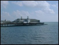
Further towards the East Cliff is Hastings Pier 910ft long and built on a frame of cast
iron. Designed by the great british pier designer Eugenius Birch (1818-1884) the pier
was opened to the public on 5th August 1892 by Lord and Lady Brassey , sadly now the
pier is unsafe to go on.
The White Rock area was until 1834, a headland that protected the town from the sea
this was demolished to allow a road to be built along the coast to join Hastings with
the wealthier St Leonards, and later allow the construction of the promenade.
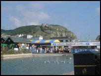
The Modern town can be seen from the seafront, then the West Hill with the Norman Castle,
and as we head further East , the Stade and its modern amusements, the Hastings Old Town
and finally the East Cliff . |
|
 Hastings Seafront is an exceptional place to view Hastings, you can walk from
Bulverhythe in the West to the East Cliff a distance of about 2 miles along the
promenade . Hastings Seafront is an exceptional place to view Hastings, you can walk from
Bulverhythe in the West to the East Cliff a distance of about 2 miles along the
promenade .
The Victorian style of St Leonards and the pier whicjh opened opened 5th August 1872, H
Hastings Castle on the West Hill , Hastings Old Town and the East Cliff can all be viewed
while walking along the promenade. |
|
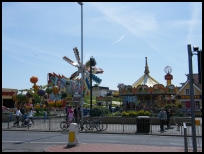 There are a number of shops and eating establishments along this stretch of the coast. There are a number of shops and eating establishments along this stretch of the coast. |
|
| Hastings Sea Front is shown as the red symbol on the map. |
|
|
Nearby Villages
(click on symbol to see the village page) |
| Village= | |
Town= | |
Recorded in Domesday= |  |
| |
|
|
Catsfield |
(Iron, Railways and Clocks) | | 5.14 miles |
|
|
Crowhurst |
(Village devastated by the Normans) | | 2.86 miles |
|
|
Fairlight |
(Firehills and Views) | | 5.42 miles |
|
|
Guestling |
(Changing guards at Buckingham Palace) | | 5.29 miles |
|
|
Hastings Bulverhythe |
(Landing place of the citizens) | | 0.77 miles |
|
|
Hastings East Cliff |
(Beautiful Views and peaceful Walks) | | 3.40 miles |
|
|
Hastings Old Town |
(The ancient Cinque Port) | | 2.21 miles |
|
|
Hastings Ore |
(Iron and the Turnpike) | | 3.19 miles |
|
|
St Leonards on Sea |
(an Edwardian family's gentile resort) | | 0.56 miles |
|
|
Hooe |
(The Haunt of Smugglers) | | 6.16 miles |
|
|
Ninfield |
(Last of the Iron Stocks) | | 5.63 miles |
|
|
Normans Bay |
(Last Invasion in 1066) | | 6.71 miles |
|
|
Pett |
(End of the Royal Military Canal) | | 6.16 miles |
|
|
Westfield |
(Bonfire Boys under suspicion) | | 4.16 miles |
|
|


